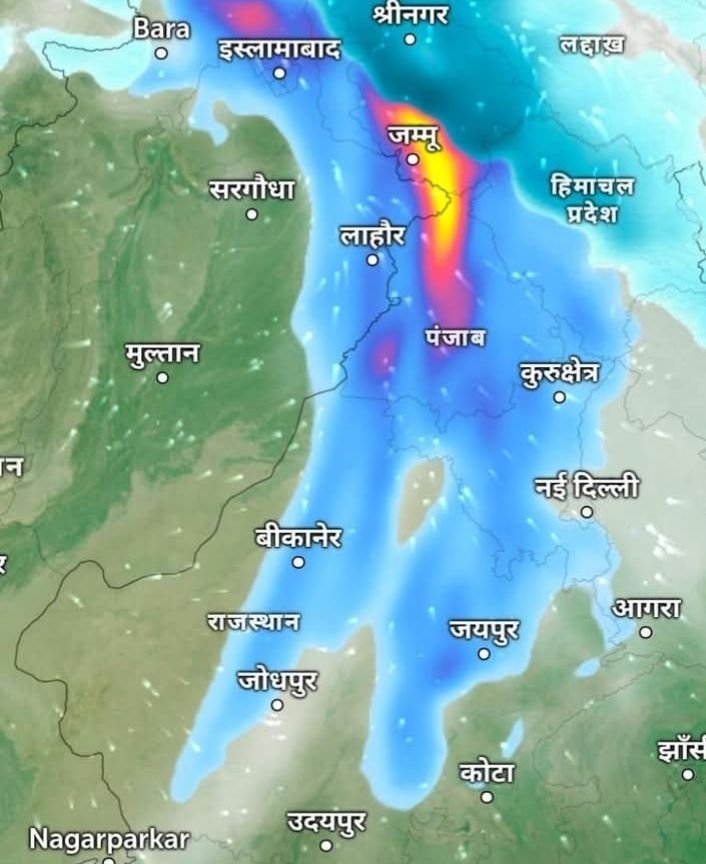
A highly unusual and extremely powerful weather system is currently influencing large parts of North India, creating intense and sharply defined patterns of rain and snowfall across the region. Meteorological maps and precipitation radar imagery indicate the presence of a strong Western Disturbance aligned with the upper-level jet stream, a combination that is rarely seen with such precision and intensity.
The weather map shows a long, narrow, and remarkably straight band of precipitation stretching from Jammu and Kashmir through Punjab and further south into parts of Rajasthan. In meteorological terms, this kind of thin yet highly intense precipitation strip is significant. Areas marked in blue on the map indicate zones of light rain or snowfall, while yellow to red shades highlight regions experiencing very heavy precipitation, either in the form of intense rainfall or heavy snowfall at higher altitudes.
Experts explain that this phenomenon is the result of a near-perfect alignment of multiple atmospheric factors. Cold air flowing at higher altitudes, abundant moisture at lower levels, and the barrier of the Himalayan ranges have come together simultaneously. This interaction has strengthened the Western Disturbance far beyond its usual impact, making it both powerful and highly focused.
In the higher reaches of Jammu and Kashmir, Himachal Pradesh, and parts of Ladakh, this system is leading to heavy to very heavy snowfall. Mountain areas are witnessing rapid accumulation of snow, which is likely to disrupt normal life, block roads, and affect essential services. Avalanches and landslides in vulnerable zones cannot be ruled out, and authorities are closely monitoring the situation.
In the plains, particularly across Punjab, Haryana, and the Delhi region, the impact is being felt through spells of moderate to heavy rain accompanied by strong winds, thunderstorms, and in some pockets, hailstorms. These weather conditions are expected to bring a sharp drop in temperatures, intensifying cold wave conditions across North India. The sudden cooling effect is likely to be felt strongly during night and early morning hours.
Rajasthan, especially northern and central parts including areas around Bikaner, Jaipur, Jodhpur, and Udaipur, is also under the influence of this system. While rainfall intensity here may vary, a noticeable dip in temperatures and chilly winds are expected to persist.
Meteorologists describe this event as a “natural marvel” not because of any supernatural cause, but due to the rare strength, structure, and alignment of the weather system. Such a sharply defined and powerful precipitation band is uncommon and is typically associated only with very strong Western Disturbances.
For the general public, the implications are clear. Travel by road and air may face disruptions, especially in hilly regions where snow accumulation can block highways and mountain passes. Farmers may see mixed impacts, with rain benefiting some crops while hail and extreme cold could damage others. Residents are advised to remain cautious, avoid unnecessary travel in affected areas, and follow advisories issued by local administrations and weather agencies.
As this powerful system continues to move across North India, its effects are expected to be felt over the next several hours to days. Authorities remain on alert, and people across the region are urged to stay prepared for rapidly changing and severe winter weather conditions.


